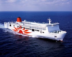
During the 2014-2019 timeframe, the European Maritime Security Agency (EMSA) registered 19,416 marine casualties and incidents involving 21,392 merchant ships under 28 European flags, which included 6210 injuries and 496 deaths. Half of these incidents happened within internal or port waters. In American waters, or on American flagged ships anywhere in the world, the U.S. Department of Transportation reported 19,586 accidents during the same period. 25,790 vessels were involved, causing 689 injuries and 194 fatalities with property damage that amounted to $7022 million.
Annually, 40% of the world’s insurance claims involve ship incidents—with an average value of $430,000 per claim. The incidents include collisions between ships, against piers, platforms, or semi-submerged objects such as lost containers or ice floes. Of further concern to national coast guards is smuggling drugs and immigrants on smaller, sometimes partly submerged vessels.
On both sides of the Atlantic, lasers were identified as a key component for increasing shipping security. Citing an “inability to observe the challenging ocean layer” with the current set of vessel sensors, the European Union launched the SMARTER (Surveillance of MARiTime surroundings through lasER) technology project in 2016.
From 2016 to 2019, a consortium coordinated by G.M.S. Global Maritime Services in London, funded with €2.5 million, worked to develop a new marine sensor from the laser ranger.
Designing a new marine sensor
Ship sensors must outperform lookouts and bridge officers to provide:
- Real-time continuous perception of the surrounding seas over 360° and longer distances
- Continuous information on the sea layer in 3D/4D in a handy and readable way
- Night and day surveillance in all environmental, weather, and traffic conditions
- Accurate data storage and reproduction for subsequent checking
A newly introduced sensor must also outperform or complement the current set of sensors aboard radars, echo-sounders, navigation, and side sonars. The International Maritime Organization (IMO) and ship classification societies must approve new sensors to be safe.
Light detection and ranging (LiDAR) aboard ships was prevailingly associated with precise measurements for science or to distance measurements in port by applying the time-of-flight (ToF) technique. On some vessels, the combination of a LiDAR that finds a target at sea for subsequent analysis and identification via a CCD camera proved useful. But when backscattered to the receiver, a ranger pulse also carries information about the target nature and behavior that can be extracted advantageously for further identification when the integral shape is considered. The integral shape can be analyzed and compared for detection and characterization using an archive of signals acquired previously. The database of prospective targets is either formed beforehand for different angles of sight or can be acquired progressively via machine learning.
The efficiency of the signal capture depends on the aperture of the receiving telescope, the area and the technology of the detector, and the chosen laser bandwidth. By implementing this technique, significant advantages to the seafarer over radar can be expected—shorter wavelengths of light allow identification of smaller scene details, including objects drifting on or barely under the sea surface (castaways, small boats, lost containers, and ice floes). More importantly, this new sensor can be a problem-solver when steaming in congested zones where radar readings are confused, such as ports or access lanes to ports. Because of the ranger exploring actively, identification does not depend on target cooperation to visibility (for example, on running lights).
First eyes on the sea
Depending on air transparency, laser range profiling of targets the size of a ship can be made up to distances on the order of 10 to 100 km.1 For smaller targets, such as lifeboats or castaways, the distances are reduced. To manufacture a compact instrument suitable for a ship to the specifications above, sensors are designed as optimum combinations of laser power, eye safety, receiver sensitivity, and profiling software.
Two recent examples of ship sensors that apply these principles are the OPAL 3D LiDAR and the LADAR (see Fig. 1). OPAL is manufactured in Canada by NEPTEC Technologies. LADAR (LAser Detection And Ranging) is produced in the UK as a result of the SMARTER program.
The OPAL works on the 1550 nm wavelength and comes in two versions—the OPAL P500 and P1000—with maximum ranges of 500 and 1000 m, respectively. OPAL is compatible with the 3DRI software development kit, an algorithms library for developing applications for target detection, tracking, and classification; data are provided in x, y, z, t, and also include intensity. The sensor is easily integrated to Electronic Chart Display and Information System (ECDIS) and the Electronic Chart System (ECS), respectively.
Expressly designed for ships, the European sensor features a 520 nm blue-green light laser exploring the marine surface layer, with some penetration below the water line because of the wing in the short wavelength.
LADAR can detect and classify objects from one yard up to one nautical mile distance, depending on how much of a target is exposed on the sea surface. An important added feature is the ability to trace submerged or semi-submerges targets down to 10 m (approximately 5.5 fathoms, depending on turbidity). An algorithm detects and characterizes targets in a process of continuous improvement of the job. This is an important asset for adapting the system to the specific, sometimes unique operating conditions of a ship.
Data are displayed in x, y, z, and t, and can be reproduced all or in part using current electronic situation awareness systems onboard, such as ECDIS, which is available on almost any merchant vessel.
Future developments
The next steps focus on increasing the sensor range by improving the signal capture process.
Both systems feature a maximum range that makes them ideal for small-and medium-sized vessels. For larger vessels they can prove useful, but not always. Considerable time is needed to stop ships with a greater mass and more kinetic energy. Even an emergency “crush stop” will take 5–10 minutes. In ideal conditions, if proceeding at moderate speed, a container ship of 266,000 loaded tonnage with an overall length of 400 m, such as the Ever Given that blocked the Suez Canal in March 2021, takes more than a nautical mile to come to a full stop.2
On many occasions, along a channel or on an arctic route, steering away from an obstacle is not a practicable option. Economies of scale favor large container vessels and tankers in both trades—extending sensor range above one nautical mile is a necessary step, either by increasing the receiving aperture or the sensor sensitivity, or both.
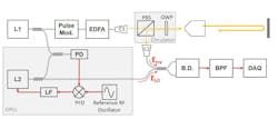
Recently, Dr. Hujan Song and his team at the Agency for Defense Development (ADD; Daejeon, South Korea) proposed a heterodyne detection scheme, which was tested in a pulse-type LiDAR (see Fig. 2). They demonstrated the potential of this technique for getting 3D images with a high frame rate at a distance of 2770 m or 1.5 nautical miles, a considerable range improvement for future ship sensors.3“The goal of our team is to increase the detection of LiDAR to a range of 1000 m or more using either coherent detection or a single photon counter,” Song says. “The sensitivity of the two scheme is similar but because of the dark count rate, single-photon detection is vulnerable to false alarms. Coherent detection is robust to false alarms, but the high complexity of the detection strategy would increase the costs. The received signal must be coupled to single mode from the free space. If alignment is not perfect, there will be a considerable loss of received signal. Also, the amplitude of coherent detection is randomly changed even though a target is fixed. We suppose this is due to the speckles of the reflected signal.”
“When utilizing coherent detection,” Song adds, “the sensitivity can be drastically improved. But costs, complexity, and coupling loss should be considered.” Investments in developing these technologies will pay: according to Fortune, this is because the global marine vessel market was $170.75 billion in size in 2021 and is projected to grow up to $188.57 billion by 2028. Merchant shipping is undergoing a revolution comparable to the introduction of steam propulsion in the 19th century.
Autonomous vessels, unmanned vessels, and remote control are spurring this revolution in photonics at sea.
ACKNOWLEDGMENT
OPAL is a trademark of NEPTEC Technologies.
REFERENCES
1. J. C. Van den Heuvel et al., Proc. SPIE, 7323, 73230Y (2009); doi:10.1117/12.8184262.
2. F. Wirz, Simulation und Optimierung des Notstopp-Manövers von Schiffen mit langsamlaufenden Zweitaktmotoren und Festpropellern, Technische Universität Hamburg, ISBN 978-3-89220-654-5 (2011).
3. H. Song et al., Rev. Sci. Instrum., 90, 125001 (2019); doi:10.1063/1.511390.
About the Author
Vittorio Lippay
Vittorio Lippay has been a member of the Institute of Physics since 2018 and a member of the Institute of Chartered Shipbrokers (London branch) since 2012.

