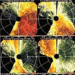
During the month of October, researchers from the US Department of Energy (DOE), the National Oceanic and Atmospheric Administration (NOAA), and several universities and private research organizations descended upon the Salt Lake Basin in Utah. Equipped with the latest high-technology measuring gear, they relentlessly poked and probed masses of night-crawling cold air, as it spilled down rock walls and crept out of canyon hideaways to replenish the cold pools that harbor airborne pollutants in urban basins.
While the month's worth of data has yet to be analyzed, preliminary observations, gathered by using Doppler lidar and a radio-acoustic sounding system (RASS), indicate that the chilling and increasingly stifling modus operandi of the cold-air outflow is beginning to unravel.
"A lot of the weather forecasters didn't think that some of these canyons produced much in the way of outflow," said Robert Banta, a research meteorologist in the environmental technology laboratory of the NOAA. "But measurements show that they do and that the outflows may only last for a couple of hours." The outflows go through cycles, appearing and disappearing as the cold air builds up in the canyons and then discharges (see figure). "Maybe that's why people didn't think that they happened in this way," he said. "But we were able to provide some insight into the role of these canyons." The researchers are planning quantitative calculations based on the data to describe the cold air movements.
The NOAA Doppler lidar was the largest of three lidar systems deployed in the basin, Banta said. The carbon dioxide (CO2) laser emitted a 10.5-µm infrared beam that scattered off of airborne particles and returned to the lidar detector with an intensity related to aerosol concentrations and a Doppler-shifted frequency related to wind speed. Unlike Doppler radar, which seeks out precipitation particles, the Doppler lidar looks for dust. "We can see in clear air where there aren't any clouds," Banta said. "But we can't see in clean air."
Designed to send out a little less than a joule of energy, the NOAA system emitted approximately 200 mJ during the experiment because of aging parts, Banta said. Nevertheless, the system averaged a 14-km viewing range (out of a hoped-for 20-km range) that still allowed the researchers to scan the entire Salt Lake basin in both azimuth and elevation from their centrally placed site.
"The lidar data are very visual, so when we did a scan, sometimes we would see streamers coming out of the canyon," Banta said. "You would just see three ribbons where the canyons were and you could tell that was where the cold-air outflow was coming from." The researchers will use the resulting data to implement several case studies.
Other instruments deployed in the month-long study of atmospheric vertical transport and mixing (VTMX) included tethered balloons and radiosondes filled with temperature, pressure, and humidity sensors. Inert gas tracers, such as sulfur hexafluoride, were also used.
"The purpose of this October experiment was to look at the buildup of these cold-air layers over night and the dissipation in the morning," Banta said. A winter observation period is also scheduled in 2001, when the longer nights will yield more persistent pools of cold air.
"The cold pool will form and it won't dissipate at night," he said. "It will hang in there and trap pollution and other things over several days. The pollution will get worse and worse as you go through the episode, whereas in October, you generally don't get these multi-day episodes and the pollution mixes vertically on a daily basis."
The overall goal of the studies is to provide meteorologists with a more accurate forecast as cold pools form and dissipate. A great deal of forecasting is based on numerical models that must be tailored for local applications, he said. "Understanding the physics of how cold pools form and dissipate, and of what goes on beneath them, will help forecasters apply the models to a local area, such as Salt Lake City or the airport."
About the Author
Hassaun A. Jones-Bey
Senior Editor and Freelance Writer
Hassaun A. Jones-Bey was a senior editor and then freelance writer for Laser Focus World.