LASER RANGING: Airborne lidar system finds hidden fault lines

A team of British and Slovenian scientists has published the results of the first airborne lidar survey flown in Europe for the purpose of mapping earthquake-prone faults. The technique is especially valuable in areas of thick forest cover, where aerial photographs are of limited use in finding and mapping surface faults. Lidar can see “beyond the tree tops”-time gating of the return pulses allows the separation of pulses reflected from the canopy of tree tops and those reflected from the ground. The lidar data can be processed to virtually deforest the landscape and image the forest-floor topography, including the traces of active faults.
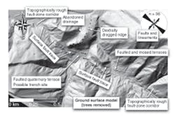
Use of lidar to locate faults was pioneered in the Puget lowlands west of Seattle, WA, and along the northern San Andreas fault system in California. The European team used lidar data to generate detailed topographic images of the Idrija and Ravne strike-slip faults in the Eastern Alps in northwest Slovenia (see figure). The area has a history of seismic activity. There have been three significant earthquakes recorded in the last 30 years: a 1976 event measuring 6.4 moment magnitude (a scale similar to but now superseding the Richter scale), a 1998 event measuring 5.6, and a 2004 event measuring 5.2. The largest earthquake ever recorded in the Alps-Dinaride junction was the 1511 western Slovenia earthquake, which measured 6.8 and was responsible for at least 12,000 deaths.
Aerial lidar surveys of the region were flown in 2004 and 2005 by the U.K. Natural Environment Research Council (NERC) Airborne Remote Sensing Facility Piper Navajo Chieftain aircraft, using an ALTM 3033 lidar instrument manufactured by Optech (Vaughan, Ont., Canada). The Idrija survey covered a swath approximately 2.2 km wide and 23 km long and was flown over a gentle valley. The Ravne Fault survey covered a swath approximately 2.4 km wide and 17 km long and was flown over a rugged mountainous region in the Krn and Vogel Ranges. The lidar system is based on a Nd:YVO4 (vanadate) laser operating at a wavelength of 1.06 µm and a repetition rate of about 30 kHz.
Data-correcting algorithm
From an operating altitude of 600 to 1000 meters, the resulting height data has an absolute accuracy of better than 15 cm, although relative accuracy is usually better. Analysis of the last-pulse-return data indicated that a significant number of returns were not coming from the ground, but rather from objects in the forest canopy. To resolve this problem, the team used an algorithm developed at TerraSolid (Jyvaskyla, Finland) to compute a surface model based on the generation of so-called triangulated irregular networks from known ground-return points.
“This study highlights the potential contribution of lidar surveying in both low-relief valley terrain and high-relief mountainous terrain to a regional seismic hazard assessment program,” says team leader Dickson Cunningham, a researcher from the University of Leicester (Leicester, England). “Many regions of the world have undiscovered seismically active faults hidden by dense forests. These include Indonesia, India, northwest North America, all Andean nations, and the Alpine countries of Europe. Unfortunately for people living in these regions, these faults can be ticking time bombs. For the first time, we are able to see how the faults connect at the surface and cut the landscape. This allows us to assess whether the faults are likely to produce large earthquakes or small events in the future.”