Airborne LIDAR maps from UH unveil possible Honduran archaeological ruins
Houston, TX--A remote region of Honduras that may contain the legendary lost city of Ciudad Blanca (see http://mosquitia.tripod.com/id1.html) has been mapped within fractions of meters using light detection and ranging (LIDAR) by a field team from the University of Houston (UH) and the National Science Foundation (NSF) National Center for Airborne Laser Mapping (NCALM). This is the first successful completion of a LIDAR survey in the Honduras Mosquitia region, one of the world’s least-explored virgin rainforests.
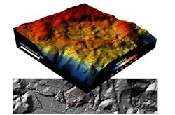
In the Honduras project, the UH team blanketed the area with as many 25 to 50 laser pulses per square meter--a total of more than four billion laser shots. A number of areas were mapped and the images collected were reduced and filtered to remove the vegetation and provide "bare earth" digital elevation models in near real‐time in the field. The digital elevation models were then used to produce geodetic images of the terrain's surface below the rainforest, and those images were searched by eye to study geomorphological features as well as potential archaeological ruins.
UH serves as the operational center for NCALM, a collaborative program between UH and the University of California at Berkeley. NCALM focuses on the collection of research quality, airborne LIDAR data for NSF principal investigators, the advancement of airborne LIDAR technology and applications and the education of students to fill positions in academic, government and commercial organizations requiring knowledge of airborne LIDAR. The Honduran mapping project was initiated by UTL Scientific LLC.
UTL project leader Steve Elkins has been fascinated with the Mosquitia rainforest since his first visit there nearly 20 years ago, but he has been frustrated by the inability of satellite imagery to see under the extremely thick canopy. He contacted researchers at UH, NCALM and Geosensing Systems Engineering (GSE) Graduate Research Program to overcome this obstacle.
In 2009, the UH researchers and a field team successfully mapped the Caracol archaeological site in Belize using airborne LIDAR. Even though the site was covered with dense rainforest, the LIDAR data captured building ruins and agricultural terraces not discovered by archaeologists working on the ground for more than 25 years.
The project has demonstrated the power of airborne laser mapping to locate archaeological ruins in regions covered with thick forest, and it appears that the method will be used widely in the years ahead.
SOURCE: University of Houston; www.uh.edu/news-events/stories/2012/june/0605LiDARHonduras.php
About the Author

Gail Overton
Senior Editor (2004-2020)
Gail has more than 30 years of engineering, marketing, product management, and editorial experience in the photonics and optical communications industry. Before joining the staff at Laser Focus World in 2004, she held many product management and product marketing roles in the fiber-optics industry, most notably at Hughes (El Segundo, CA), GTE Labs (Waltham, MA), Corning (Corning, NY), Photon Kinetics (Beaverton, OR), and Newport Corporation (Irvine, CA). During her marketing career, Gail published articles in WDM Solutions and Sensors magazine and traveled internationally to conduct product and sales training. Gail received her BS degree in physics, with an emphasis in optics, from San Diego State University in San Diego, CA in May 1986.