Teledyne combines CARIS and Optech businesses to form geospatial mapping unit
Teledyne (Vaughan, ON, Canada) has launched a geospatial group that combines its Optech and CARIS businesses. The new Teledyne Geospatial group will offer solutions to map land and sea through the integration of lidar sensors combined with software workflows. Teledyne Optech designs, develops, and manufactures advanced lidar instruments, while Teledyne CARIS has developed software for the marine geographic information system (GIS) community.
The collaboration provides mapping and data products inside one workflow, including efficiency-driving artificial intelligence (AI) algorithms and real-time quality control. Ongoing collaborations with other Teledyne businesses extends the geospatial capabilities even further.
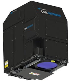
The CZMIL SuperNova, the first product from Teledyne Geospatial, integrates Optech’s bathymetric lidar with CARIS’ comprehensive processing software.
Teledyne Geospatial offerings will include turnkey systems, lidar and sonar integrated workflows, and a range of systems and solutions that support holistic, precision data collection.