POLARIMETRY: Sky conditions for Viking polarization navigation are under test

A thousand years ago, Vikings regularly sailed across the North Atlantic Ocean between Greenland, Iceland, the British Isles, North America, and mainland Europe. How they accomplished this in cloudy weather is not fully known. It was hypothesized almost 50 years ago that the Vikings used birefringent crystals to find the direction of skylight polarization that determined the position of the sun behind clouds and fog. But is this reasonable? A team of European researchers has done both psychophysical laboratory experiments and celestial polarization measurements to investigate.
The hypothesis is that the Vikings used a crystal, which they called a sunstone, as a linear polarizer. Rayleigh scattering of sunlight creates a pattern of light polarization across the sky; when the sky is clear, rotating a polarizer darkens portions of the sky periodically. The Vikings could have looked at clear patches of sky with their sunstone, or they could have measured residual polarization on a cloudy day. They would have then used the data in combination with a sundial gnomon (a known Viking device) to find the sun’s position.
The researchers—who hail from Eötvös University (Budapest, Hungary), the University of Girona (Spain), Jacobs University of Bremen (Germany), the University of Oulu (Finland), the University of Zürich (Switzerland), and the University of Würzburg (Germany)—carried out experiments with test subjects in the lab, who were shown full-sky photographs of skies with an occluded sun or at twilight with varying degrees of partial clouds. The subjects were told to guess the position of the sun; these data provided a reference showing how well sun position could be determined without a sunstone. The data, which show average errors of a few degrees or more and maximum values up to 163°, showed rather inaccurate guesses of sun position that would in many cases not be useful for navigation (although the test subjects were not experienced navigators).
In addition, a wide-field-of-view imaging polarimeter was used to examine 150,000 points in the sky (on an experiment in the Tunisian desert relating to polarization navigation by ants) for varying degrees of cloudiness, and the number of points determined for which the polarization was different from the theoretical clear-sky Rayleigh-scattering-induced polarization by less than 5°. The portion of the sky usable for polarization navigation was always higher for lower sun elevations. It was found that large parts of partly cloudy skies usually accurately follow Rayleigh’s theory.
In Hungary, as well as on an expedition to the North Pole, similar measurements were taken in fog, showing that if the fog, even if totally obscuring, is lit from above by direct sunlight, then the polarization pattern is similar to that of a clear sky. However, the degree of polarization is sometimes low enough to make polarization navigation in these cases improbable.
Polarization in overcast skies
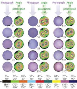
Also in Hungary and in the Arctic, polarization measurements were taken under totally overcast skies; the researchers were surprised to discover that large portions of the sky showed polarization direction similar to that of clear skies, although the degree of linear polarization was low enough to make polarization navigation difficult (see figure).
While the relevant meteorological conditions and polarization mappings have been produced, whether or not navigators with sunstones can steer a ship using a sunstone under these conditions has yet to be verified. More psychophysical laboratory work may determine how well people can sense polarization direction using birefringent crystals such as cordierite, tourmaline, or calcite, and how accurately they can take employ the information and use a Viking sundial on a cloudy or foggy day. The experiments are in progress; once complete, computer processing of the results will determine under which adverse conditions Vikings could have used a sunstone to find due north, and thus accurately span stretches of open ocean.
REFERENCE
1. G. Horváth et al., Phil. Trans. R. Soc. B, 366, 772 (2011).
About the Author
John Wallace
Senior Technical Editor (1998-2022)
John Wallace was with Laser Focus World for nearly 25 years, retiring in late June 2022. He obtained a bachelor's degree in mechanical engineering and physics at Rutgers University and a master's in optical engineering at the University of Rochester. Before becoming an editor, John worked as an engineer at RCA, Exxon, Eastman Kodak, and GCA Corporation.
