Smartphone LiDAR and TLS create 3D digital model of La Pileta Cave
La Pileta Cave in Benaoján (Málaga), Spain features thousands of graphic motifs from the Upper Paleolithic to the Bronze Age, and a team led by University of Seville researchers recently came up with a new way to create a three-dimensional (3D) model of its narrow and difficult-to-reach areas and textures.
By combining an iPhone’s LiDAR and a TLS, Daniel Antón, a postdoctoral researcher affiliated with both the University of Seville in Spain and Nottingham Trent University in the U.K., and colleagues captured and validated a 3D model of the cave with a minimum margin of error with respect to topological reference points (see video).
“With its more than 1,200 motifs spanning 30,000 years, La Pileta Cave is one of Europe’s most important rock art sites,” says Antón. “Despite its significance, its complex karstic system had never been fully documented with modern precision. Our aim was to test whether an accessible tool like a smartphone with LiDAR technology could provide rigorous 3D documentation within such a demanding environment. This represents not only a scientific opportunity but also a way to democratize archaeological documentation by lowering costs and technical barriers.”
Innovative LiDAR/TLS 3D scanning method
LiDAR works by emitting laser pulses and measuring the time they take to return (time of flight) from scanned surfaces, which generates a dense 3D point cloud (a spatial dataset with x, y, and z coordinates).
“TLS technology offers high accuracy but is costly and challenging to operate inside caves, because these surveys require setting the scanners in fixed positions,” says Antón. “Smartphone LiDAR, built into devices like the latest generations of ‘Pro’ iPhones, has a shorter range (up to 5 meters) and lower accuracy, but it is portable, affordable, and produces textured 3D meshes in real time. By validating smartphone scans against TLS and total station data, we evaluated its reliability for cave archaeology.”
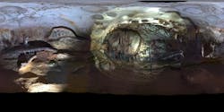
The researchers scanned key sectors of La Pileta Cave, including the “Gran Pez” chamber, using both a TLS (Leica Geosystems’ BLK360 G1) and an Apple iPhone 15 Pro with LiDAR apps (Polycam, MetaScan, 3D Scanner App).
“Each smartphone scan covered from 2 to 3 meters, which required systematic overlap and controlled lighting,” Antón explains. “The resulting models were aligned with topographic (total station) control points and compared against the TLS point cloud, used as a benchmark for the iPhone’s data. Fieldwork took several days, while post-processing and validation required weeks of analysis.”
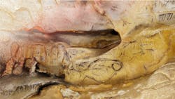
The most striking moment of this work for Antón was realizing how a simple smartphone could capture the iconic Gran Pez and surrounding paintings in remarkable detail to produce textured models that rival professional systems in visual quality.
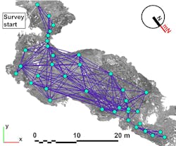
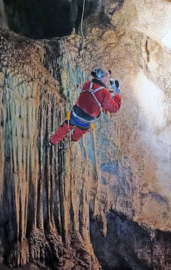
“Just as powerful were the sensations of being inside La Pileta itself,” he says. “Looking over the edge of the Gran Sima, a vast abyss that feels truly impossible for the untrained visitor, or seeing the completed iPhone survey as a whole, with its intricate network of galleries, dramatic vertical drops, and the human figure placed at the cave entrance for scale, made the experience both humbling and unforgettable.”
Illuminating the darkness
The cave environment posed several difficulties for the researchers: Illuminating the absolute darkness inside the cave for proper texture capture, removing noise data, and a limited scanner range of smartphone LiDAR technology.
“We had to resort to LED lanterns (some helmet-mounted) to evenly light the cave during the TLS survey,” says Antón. “For mobile LiDAR scanning, we developed a custom 3D-printed handheld support with LED lanterns to ensure consistent lighting and secure attachment of the device for smoother scanning.”
They discovered that their method performed very well in sectors with speleothems or complex morphologies, but offered lower accuracy in smooth areas with little relief. “Managing large datasets and aligning different scans also required substantial computational resources and careful validation,” he adds.
What does the team’s scanning method mean for the field of archaeology, cave art analysis, and the future of immersive educational experiences? “Our work demonstrates that affordable mobile devices can complement professional systems in documenting fragile heritage,” says Antón. “For archaeology, it allows access to high-quality 3D models without prohibitive costs. For cave art analysis, it provides textured digital replicas that enhance study and conservation. And for education, it enables immersive virtual experiences of otherwise inaccessible spaces, which is also particularly relevant for individuals with reduced mobility because it offers new opportunities for public engagement and heritage preservation.”
What’s next? “We plan to extend this approach to other caves and heritage sites, refining accuracy assessments, integrating LiDAR with photogrammetry to create richer models, and overcoming the limited range of smartphone LiDAR,” says Antón. “Beyond research, our goal is to create open-access 3D archives and educational platforms to make prehistoric art more widely available—while reducing physical impact on fragile sites.”
FURTHER READING
D. Antón, J. Mayoral-Valsera, M. D. Simón-Vallejo, R. Parrilla-Giráldez, and M. Cortés-Sánchez, J. Archaeol. Sci., 181, 106330 (Sep. 2025); https://doi.org/10.1016/j.jas.2025.106330.
About the Author
Sally Cole Johnson
Editor in Chief
Sally Cole Johnson, Laser Focus World’s editor in chief, is a science and technology journalist who specializes in physics and semiconductors.


