Tsunami in Japan: Flooding near Sendai
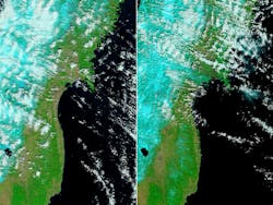
Sendai, Japan--In the aftermath of the earthquake and tsunami, satellite images from NASA's Moderate Resolution Imaging Spectroradiometer (MODIS) aboard its Earth Observing System (EOS) Terra and Aqua satellites show the extent of flooding along the coastline.
Terra MODIS acquired the left image on February 26, 2011. The coastline is clearly delineated (black or dark blue is water). The coastline in the March 12 image (right)--after the tsunami hit--is not easy to see, but a thin green line outlines the shore. This green line is higher-elevation land that is above water and, according to NASA, is probably preventing the flood of water from returning to the sea. The flood indicator on the left image illustrates how far inland the flood extends.
Source: NASA
About the Author
Stephen G. Anderson
Director, Industry Development - SPIE
Stephen Anderson is a photonics industry expert with an international background and has been actively involved with lasers and photonics for more than 30 years. As Director, Industry Development at SPIE – The international society for optics and photonics – he is responsible for tracking the photonics industry markets and technology to help define long-term strategy, while also facilitating development of SPIE’s industry activities. Before joining SPIE, Anderson was Associate Publisher and Editor in Chief of Laser Focus World and chaired the Lasers & Photonics Marketplace Seminar. Anderson also co-founded the BioOptics World brand. Anderson holds a chemistry degree from the University of York and an Executive MBA from Golden Gate University.