Watching from above

The success of unmanned surveillance aircraft over the battlefield is driving intensive efforts to greatly improve and extend this technology.
The development of unmanned aerial vehicles (UAVs), prodded by the needs of security and war, is experiencing explosive growth. Vehicles now under development may someday take the place of satellite surveillance in most military and civilian applications. At the other extreme of size, future UAVs more similar to insects than planes may relay real-time images to battlefield commanders.
A Predator’s mission
The most successful UAV to date is the Predator, a reconnaissance aircraft in service to the U.S. military (see Fig. 1). Predator is deployed particularly for missions where the risk to a human pilot is high. Such environments include not only areas of concentrated aircraft defense, but also reconnaissance across long stretches of open water, or in the presence of biological or chemical weapons.
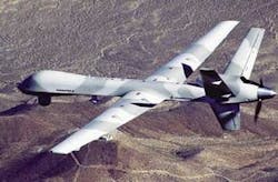
An operational Predator unit comprises four aircraft and a control and communication station staffed by more than 50 people. A complete system costs about $25 million, while an aircraft alone, which has a 49-ft wingspan and weighs more than a ton, costs somewhat more than $3 million. The prime contractor for Predator is General Atomics (San Diego, CA).
The plane is remotely controlled from the ground station, steered with a conventional joystick. The pilot reads telemetry and observes the televised 30° field of view from the fixed position video camera in the nose of the vehicle. A Predator mission can last up to 40 hours. At a range of 400 miles and a cruise speed of 70 knots, which allows about 24 hours of continuous surveillance over the target area.
UAV technology
The vehicle control and video feed is line-of-sight C-band transmission up to 100 miles distant at rates up to 274‑Mbit/s. Once over the horizon, the Predator aircraft communicates at 50 Mbit/s with ground control using a Ku-band link to an Intelsat 602 communications satellite. The bulbous nose of the plane houses the satellite dish.
Predator carries 450 lb of imaging equipment, including two video daylight cameras, with variable zoom and a 955-mm spotter lens, for real-time high-resolution color imaging. The cameras are mounted in a stabilized 360° rotating turret beneath the aircraft in an assembly called “Skyball Gimbal,” manufactured by L-3 Wescam (Burlington, Ontario, Canada). The electro-optic surveillance payload also includes high-resolution IR sensors and synthetic-aperture radar, which can see through clouds and detect vehicles parked under trees.
Image quality for aerial surveillance is judged based on the National Imagery Interpretability Rating Scale (NIIRS). The NIIRS assigns a number to a system based on the objects that it might be capable of identifying. Numbers range from 1 through 9, with an NIIRS of 1 corresponding to, say, the capacity to distinguish runways at a large airfield.
A visible system with an NIIRS of 8 would allow the operator to identify a license plate on car, or, in the IR, distinguish the arms and legs on an individual. With an NIIRS of 9, one can pick out individual leaves on a tree. These high NIIRS levels can be achieved in some circumstances by the small-format sensor systems on UAVs flying low-altitude missions.
Mission focus
Low-altitude missions at a height between about 200 and 3000 ft use cameras with short focal lengths, perhaps 25 mm for a daylight camera or 180 mm for an IR line scanner. Medium-altitude missions are flown in the altitude range of 2000 to 25,000 ft. These missions use systems with focal lengths from 180 mm up to18 in. to image an area up to 10 miles wide. Predator has an NIIRS of 6 in the visible and IR for this typical mission, which corresponds to distinguishing objects of less than 1 m in size.
High-altitude UAV missions, flown up to 50,000 ft, use focal lengths of 36 in. or greater. The Global Hawk, a larger, high-altitude UAV, uses 70-in. focal-length optics in both the visible and infrared and can achieve NIIRS imaging greater than 6. It is a critical requirement for all UAV surveillance that the optical system be flexible to adapt to rapidly changing situations, and zoom lenses are used for this reason.
Aerial surveillance imaging uses LOROP (long-range oblique photographic) cameras with multiple band E-O/IR (electro-optical/infrared) sensors. LOROP designs often make use of reflective optics, well suited to long-focal-length systems. Mirror-based designs are lightweight, accommodate a folded optical path, and are resistant to thermal changes. Their lack of chromatic aberration allows both visible and IR images to be captured with the same optics.
To lengthen exposure times, “step-stare” integration can be used. This technique uses a scanning mirror or prism to keep the line of sight stationary over a section of the ground area during the integration period. A small overlap is imposed between successive image sections to maintain image continuity.
Cutting through the haze
Over an extended range, haze from atmospheric scattering, which is predominantly blue, degrades visible-image contrast. Silicon CCD detectors, however, have their predominant response in the red to near-IR, and a significant amount of near-IR light out to 0.9 µm that is emitted by objects on the ground is available to improve contrast. Moreover, certain spectral bands in the short-wave IR (SWIR) and the mid-wave IR (MWIR) in addition to their use for nighttime imaging provide windows through atmospheric haze and water vapor.
The SWIR and MWIR wavelengths, however, become scattered in the presence of battlefield smoke. Detectors that operate in the 8- to 12-µm band can penetrate smoke, but for many years the use of sensor technology in this regime, based on intrinsic semiconductors such as indium antimonide (InSb), required the aerial platform to be uncomfortably close to the target to achieve good resolution. The advent of QWIP (quantum-well infrared photodetector) sensor technology promises not only to make this band practical for UAV surveillance, but to dramatically improve its imaging.
Quantum-well IR photodetectors rely on the properties of structures formed with multiple quantum wells. The spectral response of QWIPS are less dependant on the intrinsic material properties of the device material than on the thickness of the device layers, so materials that do not have an intrinsic photoresponse in the spectrum of interest can be used to make a detector. Sensors made with QWIP technology are much more sensitive and have higher resolution than conventional IR detectors in the same range.
Too much information
There are reportedly more than 200 Predator UAVs in service over Iraq and Afghanistan, and for several years they have been capturing video images that could conceivably reveal terrorist activity. After an initial review, however, much of this video is archived with no further examination. There is simply too much data for a complete detailed analysis.
In response, more than a dozen university and industry labs have been awarded contracts from DARPA (Defense Advanced Research Projects Agency) to develop real-time automated review of video images. Basic tasks include generic recognition of types of moving objects, such as humans and vehicles, to more complex identification of multiple-person activities. Tracking humans through crowded and confusing environments by analyzing their walking gait is an area of active study. These and similar recognition skills will then form the basis for intelligent activity recognition, vehicle tracking, and so on, for computer evaluation of airborne surveillance.
Predator could benefit immediately from such capability in its control system. One of the limitations to the system has been that, having selected an area for close-up observation, the system has a tendency to lose its orientation. Trying to pilot Predator while using the zoom lens has been compared to running while looking through a drinking straw. The ability to maintain in real time a fix on stationary objects in the moving field of view will help maintain orientation.
If it looks like a bug, it might be a UAV
There are dozens of UAVs currently in operation around the world, and hundreds more are in development. The Pentagon plans to spend $10 billion in new UAV development in the next few years. While much of this is aimed at producing large UAVs that carry weapons systems, some is intended for development in a different direction altogether: micro-UAVs the size of toys.
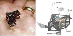
Recent breakthroughs in the understanding of insect aerodynamics has led to widespread research in building video-guided artificial bugs. The Micromechanical Flying Insect (MFI) project at the University of California at Berkeley (CA) has a goal of developing a device with a 25-mm wingspan capable of sustained autonomous flight (see Fig. 2). Using these types of vehicles for surveillance is made possible by the dramatic reduction in the size and cost of digital video cameras.
At the other extreme are large UAVs dubbed “atmospheric satellites,” that will continuously monitor a target area for days, perhaps even months at a time. Compared to satellites, UAVs can be easily repaired or upgraded. Helios, built for NASA by AeroVironment (Monrovia, CA), used 14 solar-powered electric motors to lift a payload of 100 lb to an altitude of nearly 100,000 ft (see Fig.3).
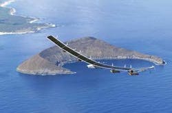
As is the case with satellites, atmospheric satellites will also be used for nonmilitary imaging. Helios was destroyed in a crash in 2003, but AeroVironment plans to introduce a commercial version as an atmospheric platform for environmental surveillance and telecommunications relay. Designed to fly for weeks or months of nonstop pollution-free flight, SkyTower, will use fuel cells to power its engines at night using energy converted from the solar cells during daylight hours.