Algorithm fuses high-resolution, high-frequency satellite data for complete, daily image maps
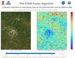
Using a new algorithm, University of Illinois (Champaign, IL) researchers may have found the solution to an age-old dilemma plaguing satellite imagery--whether to sacrifice high spatial resolution in the interest of generating images more frequently, or vice versa. The team's new tool eliminates this trade-off by fusing high-resolution and high-frequency satellite data into one integrated product, and can generate daily continuous images at 30 m going back to the year 2000.
RELATED ARTICLE: OLED microdisplays improve digital image fusion applications
Monitoring of agriculture, urban development, environmental quality and economic development are just a few ways people make use of satellite data. The new algorithm is generic enough for use in virtually any application.
In agricultural applications, imaging at 10- to 30-meter resolution is critical for farmers to see field-level rapid and subtle changes in crop conditions that affect yield, such as crop stress and disturbance after extreme weather events. Existing data have either insufficient spatial resolution or low frequency, the researchers said. Farmers usually require information with both high-resolution and near real-time occurrence.
"We struggled to find public satellite data that has both high spatial resolution and high frequency in our own research – it simply did not exist," said natural resources and environmental sciences professor and study co-author Kaiyu Guan. "So we took the initiative to produce it ourselves."
Guan teamed up with professor Jian Peng and graduate student Yunan Luo of computer science to develop an algorithm that fuses satellite images from multiple sources into continuous, daily high-resolution images. The researchers describe their methodology and findings in the journal Remote Sensing of Environment.
"We first ingested all of the available satellite data sets into Blue Waters, the National Science Foundation's leadership class supercomputer. With a click of a button to run our algorithm, what automatically comes out are daily high-resolution images available for all sorts of scientific applications," Guan said.
Previous researchers have developed methods for fusing high-resolution spatial and temporal data, but these came with limitations. Almost all of the algorithms lacked automation and could not simultaneously deal with missing pixels and temporal fusion. These drawbacks led to short-term and localized applications.
To overcome the limitations of previous methods, the team designed the algorithm to automatically integrate information from existing data. This compensates for missing information resulting from cloud coverage or data gaps. The new algorithm can create images without any missing pixels, for any site or region, by leveraging time-series information and relations with neighboring pixels.
"This can be used to study changes in agricultural productivity, ecosystem and polar ice dynamics since 2000 in much higher detail than previously possible," Peng said. "Our approach may revolutionize the use of satellite data."
SOURCE: University of Illinois; https://news.illinois.edu/view/6367/657838
About the Author

Gail Overton
Senior Editor (2004-2020)
Gail has more than 30 years of engineering, marketing, product management, and editorial experience in the photonics and optical communications industry. Before joining the staff at Laser Focus World in 2004, she held many product management and product marketing roles in the fiber-optics industry, most notably at Hughes (El Segundo, CA), GTE Labs (Waltham, MA), Corning (Corning, NY), Photon Kinetics (Beaverton, OR), and Newport Corporation (Irvine, CA). During her marketing career, Gail published articles in WDM Solutions and Sensors magazine and traveled internationally to conduct product and sales training. Gail received her BS degree in physics, with an emphasis in optics, from San Diego State University in San Diego, CA in May 1986.