Joan Lurie and Edward Jurkevics
The last decade has witnessed a revolution in the way we image and measure the Earth. Commercial firms have launched into space satellites with exotic technologies that were once reserved for classified intelligence users. Not to be outdone, foreign governments have deployed satellites with capabilities that sometimes surpass classified U.S. technologies. Meanwhile, image collection from air and street vehicles has undergone a similarly rapid evolution (see www.laserfocusworld.com/articles/317055). Total world markets for high-resolution land imaging, including value-added services, will grow from $3 billion in 2008 to $5.2 billion in 2013, an annual growth rate of 11.9%, according to Chesapeake Analytics.
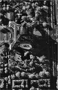
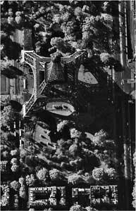
The Earth-observation business has undergone a sea change for several fundamental reasons: more imagery exists, the imagery is better in quality, and it is available to anyone with an Internet connection. The driver of the industry has been the launch of satellites collecting imagery at resolutions previously restricted to government use. The current industry leader is DigitalGlobe’s WorldView-1 satellite system with 0.5-m-resolution imagery (see figure). The company’s images have become familiar to millions of people around the world on sites like Google Earth and Google Maps. While DigitalGlobe relies on the U.S. government for approximately 50% of its revenues, the global news media has made extensive use of detailed satellite imagery, leading to worldwide awareness.
WorldView-1 represents a new business model for Earth observation. The satellite was built and launched under a contract called NextView with the National Geospatial Intelligence Agency (NGA). The imagery is used by NGA, but DigitalGlobe has the right to sell imagery of resolutions up to 0.5 m to the private sector. WorldView-1, along with DigitalGlobe’s older generation satellite QuickBird, collect up to 900,000 km2 of new imagery per day, an unprecedented rate that enables faster refresh of its imagery archive. The public company GeoEye, currently operating the Ikonos satellite and others, has a satellite similar to WorldView-1 scheduled for launch in August 2008 under the NextView contract.
Companies that provide value-added services for specific applications are growing rapidly with the availability of more imagery. In the U.S., Satellite Imaging (Houston, TX), MDA/Earthsat (Rockville, MD) and i-cubed (Fort Collins, CO) each own a big piece of the value-added remote-sensing market, while in Europe, Infoterra (Friedrichshafen, Germany), SPOT (Toulouse, France), Telespazio (Rome, Italy), and Eurimage (Rome, Italy) add value to the imagery.
A galaxy of satellites
Synthetic-aperture-radar (SAR) imaging satellites with increasingly high resolutions have been launched in the last year; the data is of high interest to military and scientists. The SAR images have several advantages over optical imagery: the radar data is largely weather independent and can be acquired at night and under cloud-covered conditions. In addition, the satellite can obtain multiple passes of data to measure minute changes in surface position using interferometric techniques, with valuable civil engineering applications such as subsidence mapping. In Europe and Canada, under arrangements with government similar to that of NextView’s, several new SAR satellites with commercial partners have recently been launched into orbit, including COSMO-SkyMed I&II (Italian), TerraSAR-X (Germany), and Radarsat II (Canada).
COSMO-SkyMed is a constellation of four SAR satellites, with two in orbit already, built by Thales Alenia Space Italia for the Italian Space Agency and the Italian Ministry of Defense. The constellation is designed to monitor and survey the entire globe for civil protection, defense, scientific, and commercial purposes. It will be particularly useful for environmental risk management and other emergencies and will thus be able to provide 24-hour, all-weather assessments of situations on a global scale. Stereo imaging is possible in a single pass, and the spotlight acquisition mode provides up to 1 m resolution.
TerraSAR-X was developed by a public-private partnership between the German Aerospace Center (DLR) and the European Aeronautic Defence and Space Company (EADS)/Astrium (Friedrichshafen, Germany), a wholly owned subsidiary of EADS. Launched in fall 2007, TerraSAR-X can image any given spot on Earth every four days, independent of weather and sunlight. In the “spotlight” mode, TerraSAR-X can take images with a resolution as accurate as 1 m.
Jörg Herrmann, managing director of Infoterra, the EADS Astrium subsidiary, says TerraSar-X will split the market with Japan’s Advanced Land-Observing Satellite (ALOS), which has a long-wavelength L-band system, and Canada’s RADARSAT-2 launched in December 2007, which uses the intermediate C-band. Infoterra expects that its main customers will be nations like Japan and the European Union, with more than half of revenue initially expected to come from military users.
Air and ground imagery
Aerial imagery has proved very popular with consumers, with Web sites like Google Maps, Microsoft MSN Live, Mapquest, and Yahoo Maps all providing high-resolution air photos for urban areas. Consumers are beginning to demand imageryand so are businesses. Companies such as i-cubed have assembled nationwide seamless mosaics of orthorectified aerial photography, and have an Internet server that delivers the data on demand to government and corporate enterprise users. Pictometry (Rochester, NY) specializes in oblique aerial photography, which is in great demand for real-estate applications on sites like zillow.com.
Aerial imagery is now commonly acquired at 6 in. resolution, and elevation postings can be established at very dense intervals because film-based manual stereocompilation of maps has become an all-digital process. Aircraft are equipped with GPS sensors and Inertial Measurement Units (IMUs) from companies like Trimble, and either digital aerial cameras from MicroSoft/Vexcel, Hexagon/Leica Geosystems, or Intergraph, or digital Lidar sensors from companies like Optech. Image processing and a large part of map compilation have been automated, and interpreters use computer editing workstations to finish maps. Companies like Intermap are operating fleets of airborne SAR sensors.
“Street Views” are rapidly gaining popularity. Microsoft released street views of Seattle and San Francisco last year, and Google has dozens of cities around the world coming on line. To try it, on a Google map of downtown San Francisco, push the “Street View” button on the map. The street-view image collection fleets are growing. New ventures are using car- and van-based systems, driving city streets, snapping pictures as they go. Equipped with GPS/IMU systems, they record the exact location each photograph was taken, and can build virtual three-dimensional worlds from the resulting photographs. Companies such as Immersive Media, EveryScape, Facet and EarthMine have raised millions of dollars to capture thousands of street-miles of imagery for major metropolitan areas. TeleAtlas, to be acquired by Tom Tom for more than $3 billion, announced that it has a fleet of 50 vehicles collecting street imagery. Proprietary Google cars with cameras on the roof have been seen in dozens of U.S. cities and as far away as New Zealand.
The market opportunity represented by high-resolution remote sensing, whether from satellite, airplanes or collected from vans, is substantial and growing. Chesapeake Analytics projects the market for commercial high-resolution satellite imagery, including value-added services, to grow from $1.1 billion in 2008 to $2.5 billion in 2013, a 16.5% annual growth rate. Satellite SAR is expected to grow even faster, from $280 million in 2008 to $780 million in 2013, a 22% annual growth rate. Airborne imagery markets will remain flat, just under $1.5 billion, as the digital revolution drives down costs and revenues. Street-level imagery is the rising star, with revenues of $90 million in 2008 projected to top $500 million in 2013, a 41% annual growth rate.
Tell us what you think about this article. Send an e-mail to [email protected].
JOAN LURIE is vice president of business development, GCC, 30 West 61st St., Apt 9A, New York, NY 10023, and EDWARD JURKEVICS is principal at Chesapeake Analytics, 3817 Roberts Lane, Arlington, VA; e-mail: [email protected]; www.chesanal.com.

