LASER ALTIMETRY
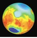
The first three-dimensional map of Mars, constructed from data gathered by an orbiting laser altimeter, shows extreme heights and depths, with features far surpassing those of Earth. The deep blue spot in the lower left of this false-color image is the Hellas impact basin, a crater nearly 9 km deep and 2100 km across. The asteroid that formed the crater left a ring of debris about 2 km thick extending 4000 km from the basin`s center.
The map was made with the Mars Orbiter Laser Altimeter (MOLA), aboard the Mars Global Surveyor, a spacecraft orbiting the Red Planet at a height of about 400 km. The global 3-D map was formed from 27 million laser measurements taken mostly in March and April of this year, combined with some measurements from summer 1998. In general, each elevation point is known to an accuracy of 13 m, with large areas of the flat northern hemisphere known to better than 2 m.
Maria Zuber, professor of planetary sciences at the Massachusetts Institute of Technology (Cambridge, MA), said she was surprised at how well the mapping team was able to measure the elevations. "The topography of Mars is now known in a global sense better than many areas of Earth`s continents," she said. "And we have not yet implemented the most-advanced post-processing techniques, so the values are going to get better."
The MOLA continues to collect about 900,000 measurements a day and will continue for at least another year and a half (see Laser Focus World, March 1999, p. 24).
The instrument, built by the Laser Remote Sensing Branch of the Laboratory for Terrestrial Physics at NASA`s Goddard Space Flight Center (Greenbelt, MD), consists of a diode-pumped, Q-switched Nd:YAG laser emitting 45-mJ pulses at 1.064 ?m, with a pulse-repetition rate of 10 Hz. A 50-cm-diameter parabolic mirror and a silicon avalanche photodiode make up the receiver. Laser spots on the planet`s surface, about 100 m in diameter, are spaced about 300 m apart.
The map shows a dramatic slope from the southern to the northern hemisphere. The heavily cratered southern hemisphere, in red and orange, is on average about 5 km higher than the north, and the overall range from the highest elevation to the lowest is about 30 km, 1.5 times the range on Earth. The finding suggests that any water that existed on ancient Mars would have flowed toward the north pole and that the smooth, low area in the north may be the bed of an extinct ocean. Scientists, however, have not yet found any beach features that would show the edge of an ocean around the basin. The area might have been formed by volcanic flows instead.
The map also shows that the south pole of Mars probably had more water ice than previously thought, though still not enough to fill the ocean that some scientists believe once existed.

