Hassi Norlén
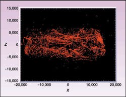
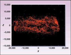
Planetary scientists have successfully used lasers to map the surfaces of planets, moons, and now an asteroid.Modern laser-ranging devices, called laser altimeters, bring a bit of truth to the ancient notion that we see things because rays emanate from our eyes, strike objects, and then bounce back. The theory of laser altimetry is simple: bounce a pulsed laser beam off a surface, measure the time it takes the light to travel back and forth, and multiply by the speed of light to get the distance. The technology was a part of the Near Earth Asteroid Rendezvous (NEAR) mission that successfully mapped the asteroid 433 Eros (see Fig. 1).
The NEAR-laser-rangefinder (NLR) science team at the Applied Physics Laboratory, Johns Hopkins University (Laurel, MD), has been sizing up Eros for the last year; the asteroid is a very complex laser-radar target and the object of study by the NLR instrument on the NEAR-Shoemaker spacecraft. Results have far exceeded everything the mission scientists hoped for, as the NLR instrument was originally slated for navigational purposes only. After launch, however, the instrument was used both as a navigational tool and to produce the first three-dimensional map of an asteroid. Successfully mapping a body shaped like 433 Eros requires not only providing accurate distance readings, but also making sense of them in connection to the target. Measuring the distance from the center-of-mass of 433 Eros to its surface requires both accurate instrumentation and a precise knowledge of the spacecraft's position.
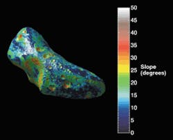
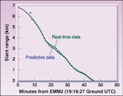
A slope map of 433 Eros calculated from the altimetry data shows several particularly level plains on the asteroid (see Fig. 2). The NEAR-Shoemaker team chose one of these as the landing site. In this maneuver, laser altimetry delivered exciting real-time data. As the NEAR-Shoemaker spacecraft touched down on 433 Eros in February of this year, the onboard laser altimeter measured the descent, continuing to send data up to touchdown (see Fig. 3). The NLR laser was fired at a repetition rate of 2 Hz throughout the descent, making possible a live plot of the range data that was immediately posted on the Internet.
The accuracy of space-based altimetry is approximately 30 cm, promising very detailed maps, but overall positional accuracy can deviate by several meters due to perturbing factors such as the gravitational distribution within a body like 433 Eros and the resulting effects on the instrument-supporting platform (the spacecraft itself). Adjusting the data for such perturbations is one of the main challenges of space-based altimetry measurement.
Laser altimetry in space
One of the first laser altimeter experiments in space was carried on the Apollo 15 mission to the moon in 1971. The device weighed in at 50 kg and contained a ruby laser emitting at 694 nm and generating a pulse every 16 seconds, a far cry from today's devices. The altimeter kept track of the distance to the moon and correlated this distance with the imaging equipment on board. Since then, many space missions have flown laser altimeters, including the Mars Global Surveyor (Mars Orbiter Laser Altimeter) mission to Mars, the NEAR mission to the asteroid 433 Eros (see Laser Focus World, November 2000, p. 22), and the Clementine mission to the moon.
There are several space-based laser altimeter systems currently under development. The Geoscience Laser Altimeter System, for example, will determine the mass balance of the polar ice sheets and their contributions to global changes in Earth's sea level. The Europa orbiter is destined to detect the tidal fluctuations predicted for the presence of a subsurface sea. And the Messenger mission to Mercury will measure that planet's slight wobble caused by its libration.
A solid surface is not necessary to get good results with a space-based laser rangefinder. If, for example, a laser altimeter were to be used to probe the depths of Jupiter's atmosphere, the return pulse would be dispersed and scattered by the atmospheric layers; however, coded in these back-scattered pulses would be data revealing the characteristics of the gaseous content of the atmosphere.
The big challenge and limitation of space missions is that every detail must be planned with regard to launch tolerances. Once past launch, a space-probe instrument must be able to perform several measurements per second for several years, survive the vacuum of space, work flawlessly without tuning or servicing, and stay frequency-locked on the proper wavelength.
Spaceborne imaging-laser altimeters may give scientists a plethora of information not generally provided by other instruments today, such as polarization, intensity, range, transformations, and continuous data-gathering capability. All this occurs at a data bandwidth demand of some 50 bit/s, compared to several hundred kilobits per second needed for a conventional imager.
Timothy Cole, lead engineer of the NLR science team, foresees future space-science missions in which conventional imaging devices are replaced by imaging-laser radar.
But such laser-based imagers alone, while gleaning elevation data and surface properties of asteroids and planets, will not reveal the constituent makeup or magnetic properties of the object. Spectrographs (gamma, optical, and so on) and magnetometers will always hold their place on any future mission.
Altimeter information and advanced modeling software will make possible the construction of very realistic models of the areas scanned. These models, in turn, will be used to detect subtle changes in geographical features over time as well as features such as ground slope. This last factor can be critical when it comes to deciding the landing spot for a spacecraft closing in on a remote planetary body. There may also be a public-relations value for the space community, as nonscientists will have another way of getting to know celestial objects up close.
HASSI NORLÉN is a science writer based at 2236 40th Street NW, Washington DC 20007; e-mail: [email protected].


